Ensemble Boosting
Ensemble boosting uses climate models to efficiently generate very intense and rare weather and climate extremes that can be analyzed for planning and stress testing of critical infrastructure.
XAIDA Webinar #16

The 16th session of our webinar will occur on March 18th, 2025 at 2PM (14:00) CET. Oana-Iuliana Popescu (TU Dresden, TU Berlin) will talk about ‘Causal discovery with endogenous context variables’
Check out the details to attend, discuss and follow the discussion!
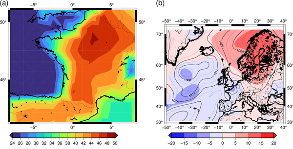
Scenario of an extreme heat: Paris 50°C to Summer Olympics heatwave

The 2024 Summer Olympic Games took place during the hottest part of the year in the Paris area, and raised the question how hot heatwaves over Paris could be in the near future. In recent years, the mid-latitudes of the Northern Hemisphere have experienced several intense heatwaves since the major one in 2003. These heatwaves have caused unexpected environmental and health problems. In addition, the questions arose whether, when and in what condition temperatures could exceed 50°C in Paris at the 2100 horizon, and thus what the city of Paris needed to be prepared for.
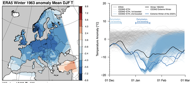
Scenario for an extreme Winter like 1962-1963

The winter of 1962/1963 was the coldest winter on record in many central European countries, based on the average temperatures for December, January, and February. The extreme cold affected large parts of mainland Europe, stretching from the eastern and northern Baltic Sea regions to western Europe. This harsh winter had significant and well-documented effects on both people and ecosystems. Can such a winter still happen?
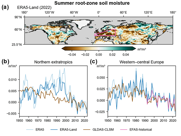
European Drought and Heatwave in 2022

In the summer of 2022, western and central Europe faced significant soil moisture shortages due to a combination of low rainfall and high temperatures. This drought was one of the worst the region had seen since at least the mid-1900s, leading to the question whether and to what extent this is caused by our changing climate.
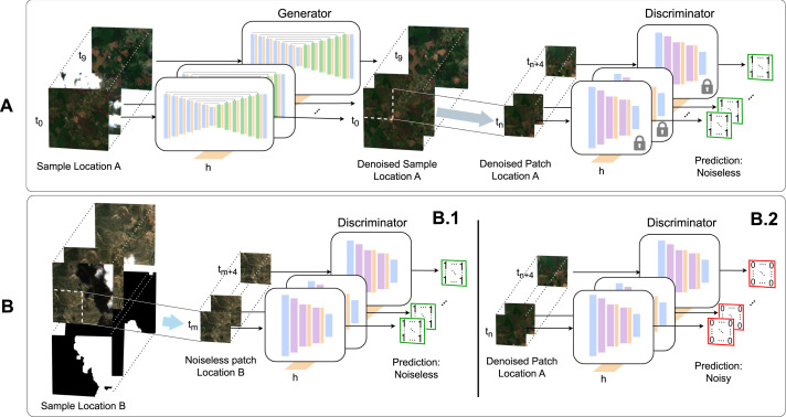
Paper: Generative networks for spatio-temporal gap filling of Sentinel-2 reflectances

Read the paper: Generative networks for spatio-temporal gap filling of Sentinel-2 reflectances
« Earth observation from satellite sensors offers the possibility to monitor natural ecosystems by deriving spatially explicit and temporally resolved biogeophysical parameters. Optical remote sensing, however, suffers from missing data mainly due to the presence of clouds, sensor malfunctioning, and atmospheric conditions. This study proposes a novel deep learning architecture to address gap filling of satellite reflectances, more precisely the visible and near-infrared bands, and illustrates its performance at high-resolution Sentinel-2 data. (…) »
Teaching Material: Climate models help us plan sports events

XAIDA is collaborating with the PSTT (Primary Science Teaching Trusts) collaborators. PSTT produces some teaching material based on XAIDA work.
This work is based on the work leading on Paris 2024 Olympics simulations published by XAIDA scientists.
Read more on Climate models help us plan sports events!
XAIDA Webinar #15

The 15th session of our webinar will occur on February 18th, 2025 at 2PM (14:00) CET. Aglaé Jézéquel (LMD-IPSL) will talk about ‘Broadening the scope of anthropogenic influence in extreme event attribution?’
Check out the details to attend, discuss and follow the discussion!
XAIDA Webinar #14

The 14th session of our webinar will occur on January 21st, 2025 at 2PM (14:00) CET. Svenja Seeber (ETH Zurich) will talk about ‘How extreme was the global heat in 2023/24?’
Check out the details to attend, discuss and follow the discussion!
XAIDA Webinar #13

The 13th session of our webinar will occur on January 7th, 2025 at 2PM (14:00) CET. Dominik Schumacher (ETH Zurich) will talk about ‘Storylines of heat and drought’
Check out the details to attend, discuss and follow the discussion!
