Paper: Attributing Venice Acqua Alta events to a changing climate and evaluating the efficacy of MoSE adaptation strategy
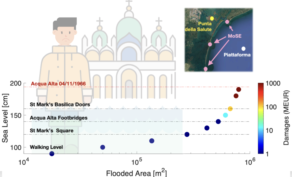
Read the paper: This research employs an innovative approach by utilizing analogues of atmospheric patterns to scrutinize four notable Acqua Alta events in the Venice lagoon, specifically those connected with intense Mediterranean cyclones that transpired in 1966, 2008, 2018, and 2019. The findings provide compelling evidence that modifications in atmospheric circulation, while not solely attributable to human activities, are undeniably linked to the increased severity of these events, thereby illuminating the vulnerability of Venice to the impacts of climate change. Furthermore, the study conducts a comprehensive assessment of the MoSE system, a crucial adaptation infrastructure designed to mitigate flooding in Venice, and underscores its effectiveness in protecting the city against events with historical analogues, particularly those akin to the catastrophic 1966 flood.
CHANGE OF GOVERNANCE

Life of the project – We are happy to announce that Dim COUMOU is now the Scientific Coordinator of the XAIDA Project, unanimously approved by the Consortium. Read more to know the context and the other changes in the XAIDA governance.
Paper: Heat Extremes in Western Europe warmed faster than simulated
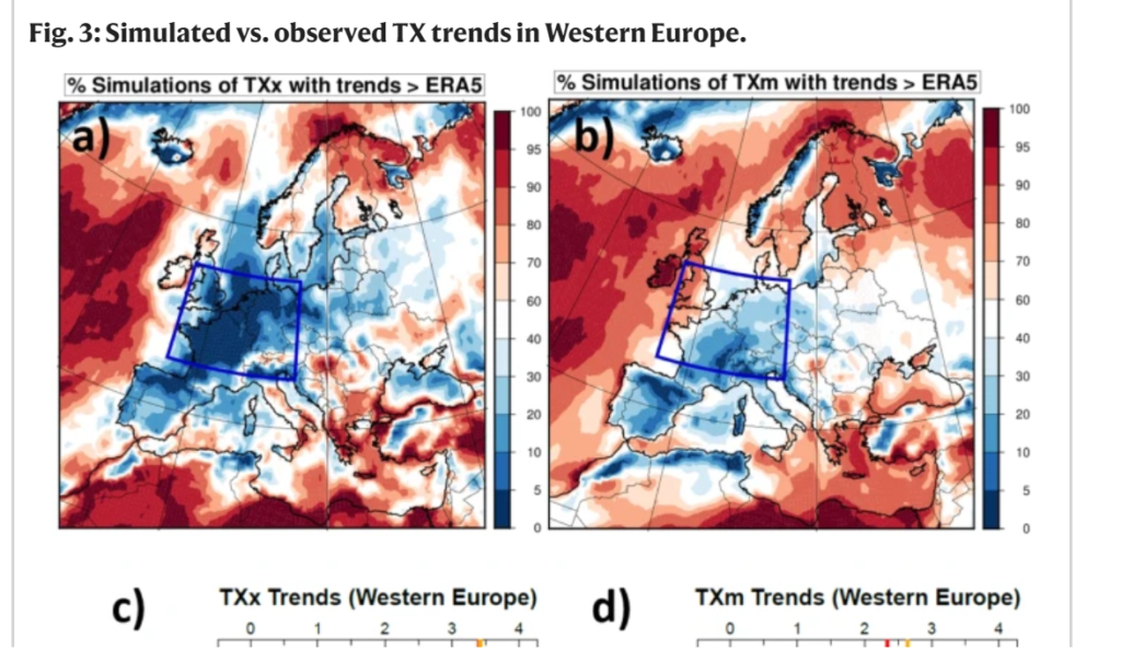
Read the paper: Over the last 70 years, extreme heat in Western Europe has intensified with 3.4°C per degree global warming. A rate much larger than nearly anywhere else. Very few models capture the observed trend. None of them captures the large contribution from trends in atmospheric circulation.
The mismatch can be due to an underestimated circulation response to external forcing or underestimated unforced internal variability, or both. The former implies that heat extremes continue to intensify at an extreme rate, the latter that the trend continues but may slow down.
GENERAL ASSEMBLY 2023

Located in València, Spain, the XAIDA’s Second General Assembly took place in October 2023.
CLIMAMETER, A RAPID WEATHER EXTREME EVENT FRAMEWORK
ClimaMeter is a rapid framework for understanding extreme weather events in a changing climate based on looking at similar past weather situation (©ClimaMeter). The platform is a collaboration between 4 institutions (LSCE-IPSL, ICTP, INGV and Uppsala University), 2 EU funded projects (XAIDA and EDIPI) and a French CNRS funded project (CROIRE).
DESPITE GLOBAL WARMING, COLD SPELLS SUCH AS WITNESSED IN THE 1980’s IN WESTERN EUROPE ARE STILL POSSIBLE
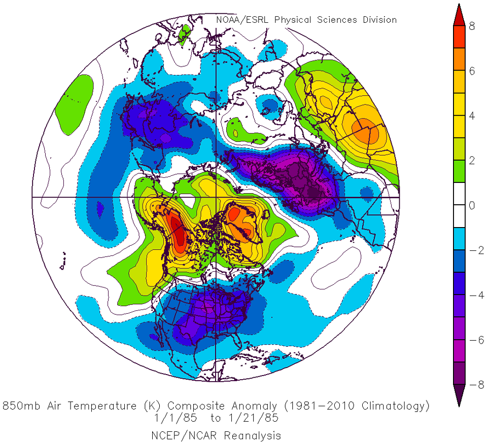
Extreme cold spells are still possible today in Western Europe, even with current warming trends.
The atmospheric circulation patterns that drive extreme low temperatures, e.g. as in January 1985, remain possible in current winters.
Under such conditions we anticipate that with current regional warming trends, temperatures would only be about 1.4°C warmer than in 1985, with potential impacts on the electricity grid, and health.
As an example, a circulation-induced 1985-like cold spell in today’s climate would likely stand at around -9°C over France for minimum temperatures, which would still be amongst the 5-10 coldest cold spells observed in the past five decades.
The “Medicanes” (Mediterranean Hurricanes) and climate change
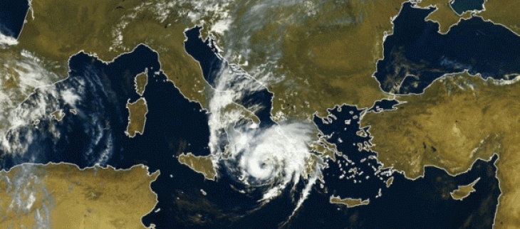
Medicanes are Mediterranean cyclones whose characteristics resemble those of tropical cyclones. They are often associated with hurricane-force winds and heavy precipitation. With a frequency of 1-2 per year, it is a challenge to determine whether their frequency should increase or decrease in a warmer world. Their intensity is however projected to increase due to the warming projections for the Mediterranean sea, the main source of energy for medicanes.
GENERAL ASSEMBLY 2022
Located in Sorbonne University, Paris France, the XAIDA’s First General Assembly took place from 12 to 14 October 2022, in a hybride format.
Extreme precipitation Italy 2002
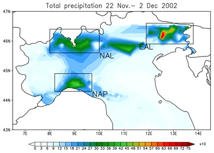
In the second part of November 2002, the synoptic situation over the Mediterranean was characterized by a sequence of perturbations entering the area from the North Atlantic. In particular, the persistence of an upper-level North-Atlantic trough between the 23th and 27th of the month, set the conditions for very heavy precipitation over North Italy with high ground impact over some areas and floods (i.e. Milan, Pordenone). The impact at ground was possibly amplified by the ground wet saturation for precipitations that occurred in the previous period. The evolution of the perturbation entering the Mediterranean basin on Nov. the 24th was very slow due to a steady North Africa high pressure blocking the central-east basin side.
Extreme precipitation France 2002
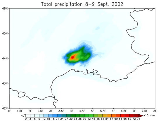
This event affected the South of France during September 8th-9th, 2002, and it was characterized by the formation and evolution of a major mesoscale convective system (MCS). The event caused one of the most important flood recorded in the Cevennes-Vivarais region, with 24 people killed and economic loss estimated at 1.2 billion euros (Huet et al., 2003). The MCS was driven by a deep low pressure extending from Scotland to the western Mediterranean with an associated surface cold front. The prefrontal flow induced relatively warm and humid air into the South of France, feeding the convective system. The combination of cold temperature at mid-levels (850 hPa) and humidity at low-to-mid levels were the perfect ingredients for convection to form during the event. A further injection of wet air due to the circulation around the Southern Alps contributed to intensify the event. The maximum values of precipitation exceeded 600 mm in the region of Anduze and Alès (Delrieu et al., 2005).

