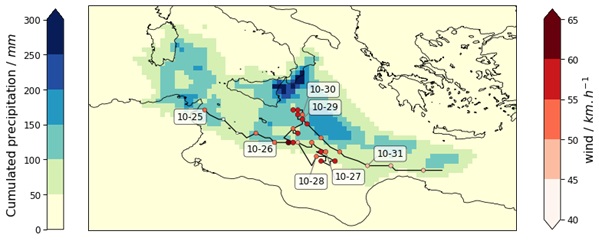
Event definition
While there is no agreed definition of Medicanes, extratropical and tropical cyclones can be tracked by using several methodologies, mostly based on the identification of a pressure minimum and a cyclonic structure. Having identified the track in Figure 1 in the work under review here, we will consider the period October 25 to October 31 and the region shown in the box of Figure 1 and the two variables (cumulated precipitation and wind speed) to attribute the impacts of Apollo.
Objectives
XAIDA aims at improving the understanding of the driving physical mechanisms of this event, by attributing the whole trajectory of Apollo and its impacts to climate change, rather than performing the attribution of the related meteorological variables such as rainfall, winds and storm surges at specific locations.
XAIDA aims to identify more clearly which aspects of the physical event cause the impacts, by using methods based on the recognition of similar cyclones in past, present and future climates. These methods are based on analogues search that could be performed using standard geometrical methods of artificial intelligence measures of similarities, or even measures of similarities based on their impacts.
XAIDA is also interested in understanding which datasets are better suited for attributing dynamics and impacts of tropical cyclones to climate change: indeed global climate models misrepresent major hurricanes because of the insufficient horizontal resolution, while regional high resolutions climate models may miss the large scale triggers of the hurricanes. Statistical and dynamical methodologies such as bias corrections and downscaling can, in both regional and global climate models, improve the representation of the hurricanes to be used for attribution.
Study results
Using the ERA5 dataset, Faranda et al (2022) analyzed how the cyclonic circulation associated with Apollo compares in past and present climates. They chose similar circulation patterns (analogues) without focusing on whether they were tropical or extratropical.
They found a few differences between the present (factual) and past (counterfactual) climate, even though the average pressure values for these analogues in both the present and past climates were not as low as Apollo’s.
- Apollo’s circulation pattern is very rare compared to the rest of the analogues, meaning it is a « black swan » event, and the results must be interpreted cautiously.
- There is a small but noticeable increase in pressure over the northern part of the area, meaning the factual cyclones were weaker or shifted further south compared to counterfactual ones.
- temperatures are significantly warmer in the current climate, especially over Sicily and the southern Mediterranean. This warming led to more rainfall in the present climate, likely because the warmer sea provided more heat and moisture.
- There were no notable changes in the predictability index or persistence.
- More analogues were observed occurring in September in the factual period , which is the Mediterranean’s warmest month. This warmth encourages strong convection and cyclonic activity, potentially intensifying rainfall. For Apollo, this effect was particularly evident over mountain ranges like Etna and Peloritani in Sicily.
- No significant differences were found in the ENSO (El Niño-Southern Oscillation) or AMO (Atlantic Multidecadal Oscillation) patterns
Conclusion
Overall, the analysis supports the idea that cyclones near Sicily may bring more intense rainfall in the current climate, driven by warmer temperatures and more frequent September cyclones. However, because Apollo’s pattern is so rare, we urge caution when interpreting these results.
References
Faranda, D., Bourdin, S., Ginesta, M., Krouma, M., Noyelle, R., Pons, F., Yiou, P., and Messori, G.: A climate-change attribution retrospective of some impactful weather extremes of 2021, Weather Clim. Dynam., 3, 1311–1340, https://doi.org/10.5194/wcd-3-1311-2022, 2022.
Faranda,D. et al.. Correcting biases in tropical cyclone intensities in low-resolution datasets using dynamical systems metrics. Climate Dynamics, 2023 ,https://link.springer.com/article/10.1007/s00382-023-06794-8 .