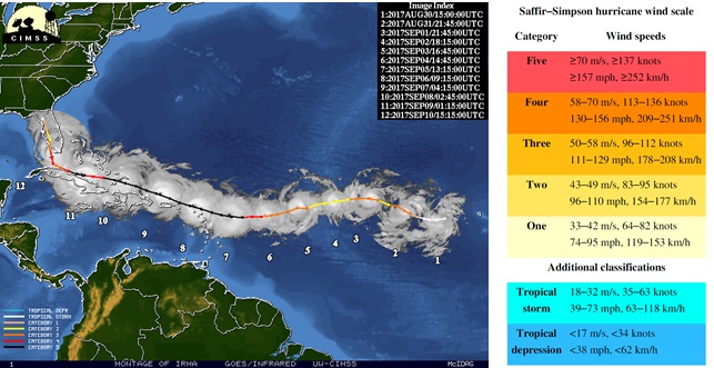
Event definition
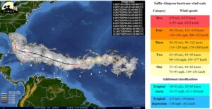
Tropical cyclones are tracked and categorized by the Saffir-Simpson scale for tropical cyclones. It is graded into five levels of intensity, corresponding to standardized wind speed ranges. To classify a cyclone on this scale, sustained wind speed is recorded for one minute at a height of 10 meters , the resulting average is compared with the intervals (See intensity categories ). For Irma, we will select all the phases where Irma is categorized as Major Hurricane (category above or equal to 3), this corresponds to sustained winds above 178 km/h and to severe impacts, namely i) structural damage to small residences and utility buildings, ii) flooding near the coast destroys smaller structures, terrain may be flooded well inland, iii) near-total to total power loss is likely for up to several weeks and water will likely also be lost or contaminated.
Objectives
XAIDA aims at improving the understanding of the driving physical mechanisms of this event, by attributing the whole trajectory of Irma and its impacts to climate change, rather than performing the attribution of the related meteorological variables such as rainfall, winds and storm surges at specific locations.
XAIDA aims to identify more clearly which aspects of the physical event cause the impacts, by using methods based on the recognition of similar cyclones in past, present and future climates. These methods are based on analogues search that could be performed using standard geometrical methods of artificial intelligence measures of similarities, or even measures of similarities based on their impacts.
XAIDA is also interested in understanding which datasets are better suited for attributing dynamics and impacts of tropical cyclones to climate change: indeed global climate models misrepresent major hurricanes because of the insufficient horizontal resolution, while regional high resolutions climate models may miss the large scale triggers of the hurricanes. Statistical and dynamical methodologies such as bias corrections and downscaling can, in both regional and global climate models, improve the representation of the hurricanes to be used for attribution.
Study results
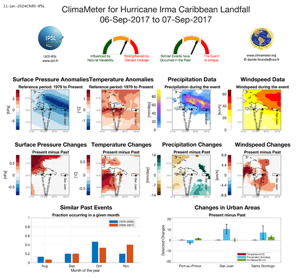
Faranda et al (2024) used the Climameter framework to study Hurricane Irma. Using analogues, they analyzed how low-pressure systems similar to the one that caused Hurricane Irma’s landfall in the Caribbean have changed in recent years (2001–2022) compared to the past (1979–2000) in the region between [-75°E to -65°E, 13°N to 23°N]. They found that:
- Hurricane Irma was a very uncommon event, and therefore care has to be taken in interpreting the attribution results.
- Surface Pressure: Cyclone intensity hasn’t changed significantly overall, except in a few small areas.
- Precipitation: Similar storms now bring heavier rainfall (0–13 mm/day) compared to the past, but this increase is significant only in limited parts of the region.
- Wind Speed: These storms now have faster winds, increasing by about 4–8 km/h.
- Natural climate factors, like the Atlantic Multidecadal Oscillation, may have influenced these changes.