Extreme precipitation Italy 2002
In the second part of November 2002, the synoptic situation over the Mediterranean was characterized by a sequence of perturbations entering the area from the North Atlantic. In particular, the persistence of an upper-level North-Atlantic trough between the 23th and 27th of the month, set the conditions for very heavy precipitation over North Italy with high ground impact over some areas and floods (i.e. Milan, Pordenone). The impact at ground was possibly amplified by the ground wet saturation for precipitations that occurred in the previous period. The evolution of the perturbation entering the Mediterranean basin on Nov. the 24th was very slow due to a steady North Africa high pressure blocking the central-east basin side.
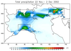
The prefrontal humid and warm flow associated with the trough, invested North of Italy and the interaction with the orography induced precipitation across the whole region. The persistence of the precipitation for a long time, caused very high rain accumulation, especially in mountainous areas (Fig. 1) with peaks of day precipitation of 170 mm in Liguria on Nov. 24 over Northern Apennines region (NAP on Fig. 1), 130 mm in Northern Alps (NAL) on Nov. 25th and of about 320 mm over Eastern Alps (EAL) on Nov. 25. On November 26th a cut-off low pressure isolated over Sardinia (West Mediterranean), evolving south-eastward, and continued to feed Northern regions with wet-unstable flow which made the precipitation still persisting there. On the next days the low pressure became shallower and moved farther to South-East, while a second trough entered the western Europe on Nov. 28th, thus inducing wet, warm and unstable air-flow over the western basin and North Italy, again with associated precipitation. The total accumulation for the period (10 days of persisting rain) reached very high peaks with about 400 total mm in NAL, 470 mm in NAP, and more than 700 mm in EAL (Fig. 1).
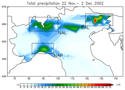
Figure1: Accumulated precipitation during the period 22 November to 02 December 2002 from high resolution observations (GRIPHO, 3km, Fantini, 2019); color bar unit is x10mm ; the black boxes show areas of maximum precipitation over the North Alps (NAL), North Apennines (NAP) and Eastern Alps (EAL).
Event definition
Heavy precipitation is an episode of abnormally high rain or snow (95th percentile). The definition of « extreme » is a statistical concept that varies depending on location, season, and length of the historical record. The mechanisms (perturbation, air mass, water content, instability, interaction with local forcings, persistence, etc.) that generate a heavy/extreme event can be very different among different regions. Same amount of heavy/extreme precipitation over different areas can lead to different responses at ground (in terms of floods). In the case presented here the key factor for the event to be extreme is for sure persistence of a very common perturbation for the area during the fall period.
Objectives
XAIDA aims at developing an Artificial Intelligence based method to detect such kinds of events and in combination with high resolution convection permitting modeling dataset at emulating the costly dynamical models in representing them. By means of the AI methodology XAIDA will try to better understand the physical mechanisms/key factors which drive the most extreme events among the whole population of precipitating events over Europe.
XAIDA also aims to understand if such events observed in the present day period can be projected in a future climate scenario with the AI methodology and if the method can be extended to directly connect the climate variables to the observed hazard (flood) both in present and future climate conditions.
XAIDA also aims to develop an AI based method to attribute such events to climate change; the identifications of their driving mechanisms/ingredients would allow to eventually perform such attribution trough key-variables in addition to precipitation.
Study results
Coppola et al (2024) used the Climameter analogues method to find differences between the present (2001–2023) and the past (1979–2001) climate in the region [0°E 22°E 34°N 48°N]. They conclude this was a very exceptional event in terms of meteorological conditions. Mediterranean depressions similar to that causing multiple floods in Italy in October 2024, show increased precipitation (up to 10 mm/day, or up to 25% more precipitation) and produce stronger winds (up to 6 km/h, representing a 10% increase in wind strength) in the present compared to the past. This was a very exceptional event in terms of meteorological conditions. Natural variability alone cannot explain the changes in precipitation and wind associated with this very exceptional meteorological conditions
Fantini (2019) used a multimodel approach to study the impact of flood hazard over Iraly, involving three steps: i) Hydrological Modeling, using multiple sources of precipitation data to simulate water discharge over a region or river basin for extended periods; ii) Hydrodynamic Modeling, in which the discharge data was then used in a hydrodynamic model to create flood extent maps and, if needed, additional details like flood depth or flow speed; iii) Extreme Value Analysis, using statistical methods to estimate return periods for extreme flood events, even with shorter observation records. The model chain containsn regional, hydrological and hydraulic models. To provide high-quality precipitation data for the hydrological model, they created a new dataset called GRIPHO(GRidded Italian Precipitation Hourly Observations).
Both a boundary simulation using ERA-Interim data and a future scenario simulation driven by HadGEM (RCP8.5) matched observations for precipitation and temperature, showing good results for both average and extreme conditions. Projections suggest that while average precipitation may decrease in some areas, extreme precipitation is expected to increase overall.
Hydrological simulations using observed and climate model data revealed that the CHyM model performed well against discharge station data. For the future projections, mean discharge is expected to increase in northern Italy in winter and decrease in summer, reflecting seasonal rainfall shifts in the Po River basin. Maximum yearly discharges may rise by 50% in winter and autumn in many regions. Furthermore, 100-year flood discharges could more than double across Italy by the century’s end and extreme flood events (e.g., 100-year floods) may increase by over 500% in some rivers, including the Po. Preliminary flood maps for various return periods align with regional agency products but are based on a consistent, scientifically robust method. These findings underscore significant flood risks in Italy due to climate change, highlighting the urgency of improved planning and mitigation strategies.
References
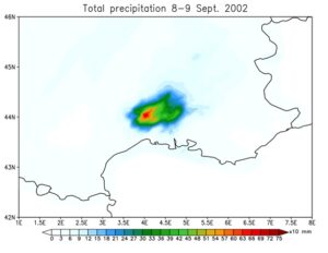
Delrieu, G., Nicol, J., Yates, E., Kirstetter, P., Creutin, J., Anquetin, S., Obled, C., Saulnier, G., Ducrocq, V., Gaume, E., Payrastre, O., Andrieu, H., Ayral, P., Bouvier, C., Neppel, L., Livet, M., Lang, M., du-Châtelet, J. P., Walpersdorf, A., & Wobrock, W. (2005). The Catastrophic Flash-Flood Event of 8–9 September 2002 in the Gard Region, France: A First Case Study for the Cévennes–Vivarais Mediterranean Hydrometeorological Observatory, Journal of Hydrometeorology, 6(1), 34-52.
Huet, P., Martin, X., Prime, J.-L., Foin, P., Laurain, C., and Cannard, P.: Retour d’exp erience des crues de spetembre 2002 dans les departements du Gard, de l’Herault, du Vaucluse, des Bouches-du-Rhone, de l’Ardeche et de la Drome. (In French), Tech. rep., Ministere de l’ecologie et du developpement durable, Republique Francaise, 2003
Fumière Q, Déqué M, Nuissier O, Somot S, Alias A, Caillaud C, Laurantin O, Seity Y (2019) Extreme rainfall in Mediterranean France during the fall: added-value of the CNRM-AROME Convection-Permitting Regional Climate Model. Clim Dyn. https:// doi.org/10.1007/s00382-019-04898-8)
Tabary P, Dupuy P, L’Henaff G et al (2012) A 10-year (1997–2006) reanalysis of quantitative precipitation estimation over France: methodology and first results. IAHS Publ. 351:255–260
![]() This project has received funding from the European Union’s Horizon 2020 research and innovation programme under grant agreement No 101003469.
This project has received funding from the European Union’s Horizon 2020 research and innovation programme under grant agreement No 101003469.