Scenario of an extreme heat: Paris 50°C to Summer Olympics heatwave
The 2024 Summer Olympic Games took place during the hottest part of the year in the Paris area, and raised the question how hot heatwaves over Paris could be in the near future. In recent years, the mid-latitudes of the Northern Hemisphere have experienced several intense heatwaves since the major one in 2003. These heatwaves have caused unexpected environmental and health problems. In addition, the questions arose whether, when and in what condition temperatures could exceed 50°C in Paris at the 2100 horizon, and thus what the city of Paris needed to be prepared for.
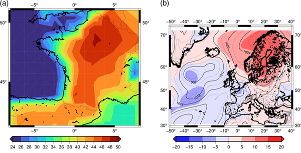
Scenario for an extreme Winter like 1962-1963
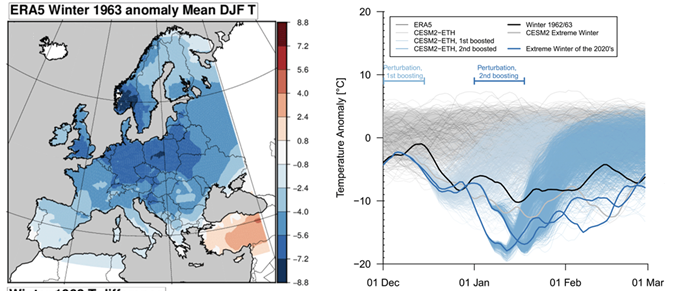
The winter of 1962/1963 was the coldest winter on record in many central European countries, based on the average temperatures for December, January, and February. The extreme cold affected large parts of mainland Europe, stretching from the eastern and northern Baltic Sea regions to western Europe. This harsh winter had significant and well-documented effects on both people and ecosystems. Can such a winter still happen?
European Drought and Heatwave in 2022
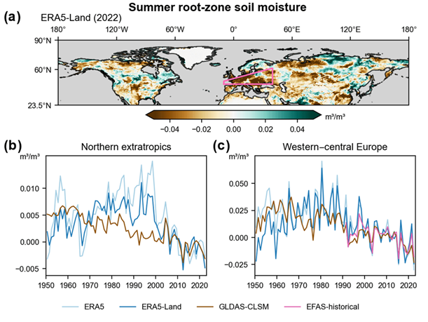
In the summer of 2022, western and central Europe faced significant soil moisture shortages due to a combination of low rainfall and high temperatures. This drought was one of the worst the region had seen since at least the mid-1900s, leading to the question whether and to what extent this is caused by our changing climate.
Extreme precipitation Italy 2002
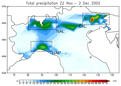
In the second part of November 2002, the synoptic situation over the Mediterranean was characterized by a sequence of perturbations entering the area from the North Atlantic. In particular, the persistence of an upper-level North-Atlantic trough between the 23th and 27th of the month, set the conditions for very heavy precipitation over North Italy with high ground impact over some areas and floods (i.e. Milan, Pordenone). The impact at ground was possibly amplified by the ground wet saturation for precipitations that occurred in the previous period. The evolution of the perturbation entering the Mediterranean basin on Nov. the 24th was very slow due to a steady North Africa high pressure blocking the central-east basin side.
Extreme precipitation France 2002
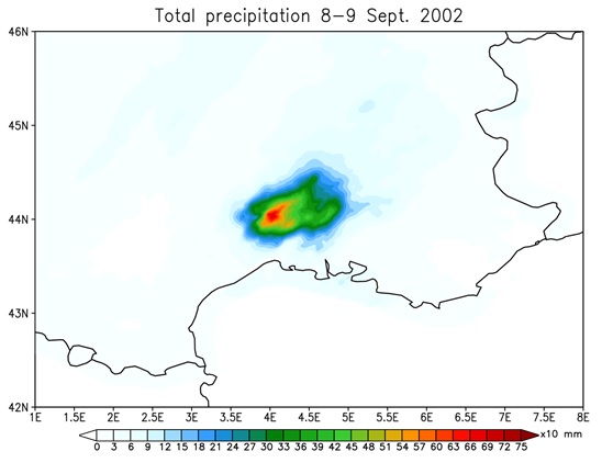
This event affected the South of France during September 8th-9th, 2002, and it was characterized by the formation and evolution of a major mesoscale convective system (MCS). The event caused one of the most important flood recorded in the Cevennes-Vivarais region, with 24 people killed and economic loss estimated at 1.2 billion euros (Huet et al., 2003). The MCS was driven by a deep low pressure extending from Scotland to the western Mediterranean with an associated surface cold front. The prefrontal flow induced relatively warm and humid air into the South of France, feeding the convective system. The combination of cold temperature at mid-levels (850 hPa) and humidity at low-to-mid levels were the perfect ingredients for convection to form during the event. A further injection of wet air due to the circulation around the Southern Alps contributed to intensify the event. The maximum values of precipitation exceeded 600 mm in the region of Anduze and Alès (Delrieu et al., 2005).
Hurricane Irma
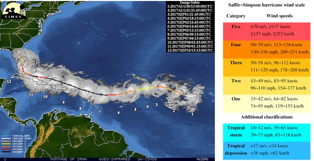
Hurricane Irma was a Cape Verde-type hurricane, the most intense hurricane observed in the Atlantic Ocean since Hurricane Dean in 2007[2]. It was also the most powerful Atlantic hurricane to hit the U.S. since Katrina in 2005 and the first major hurricane (Category 3 or higher on the Saffir-Simpson scale) to make landfall in Florida since Hurricane Wilma in 2005. Irma was the ninth named tropical storm, the fourth hurricane, and the second major hurricane of the 2017 season.
Combined cold and wind drought winters
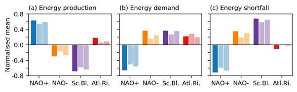
Winter cold spells in Europe can be accompanied by anomalously weak winds. Usually, the reason is a so-called “blocked” atmospheric circulation, leading to advection of cold air downstream and a weaker than normal warming westerly flow. This creates a situation where energy demand is high, but power production from renewables is low, leading to higher risk of energy shortfall (Figure 1). With the transition towards more renewable energies in Europe, the energy sector will also become more weather-dependent, making it necessary to understand potential changes in the frequency and intensity of combined cold/wind drought winters.
Cold Outbreak in Europe in spring 2021
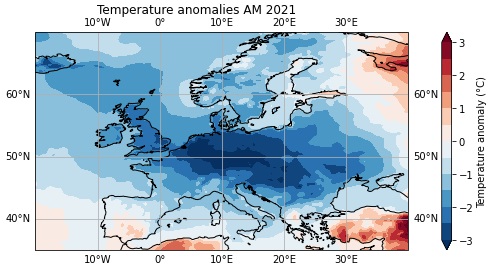
The spring of 2021 showed anomalously low temperatures across large areas of Europe (see Figure 1). These extreme temperatures likely contributed to impacts in different sectors (energy, health, agriculture). In particular, several frost nights in early April in France caused damage to the regional wine industry as the cold temperatures occurred after anomalously warm temperatures in March, thus, right in the sensitive phase after bud-burst.
Pacific North American heatwave 2021
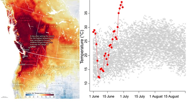
During the last days of July 2021 a region in the Northwestern US and southwestern Canada experienced temperatures that have never been previously observed in this region, with records broken in many places by several degrees (Philip et al. 2021). A new all-time Canadian temperature record of 49.6°C was set in the town of Lytton, British Columbia. The same town was strongly affected and partly destroyed by one of the severe wildfires that occurred during and after the heatwave. The Pacific Northwest heatwave further contributed to a sharp increase in heat-related excess mortality. The Pacific Northwest heat wave is one of a series of record-shattering heat extremes that, based on the previous observational record, may have been deemed impossible.
Medicane Apollo
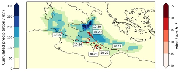
Medicane Apollo (named by a consortium of European meteorological services) formed on October 28th in the Jonian sea, offshore Sicily, from a low pressure disturbance which was very active in the days previous the formation of the Medicane. This low pressure system was isolated near the Balearic islands around 22nd of October and then moved on the Central Mediterranean sea producing self-regenerating thunderstorms in the area of Catania on the 24th of October.